Aotearoa New Zealand Ocean – the meeting place of cultures, tectonic plates, subtropical to polar oceans and climate systems
The meeting place
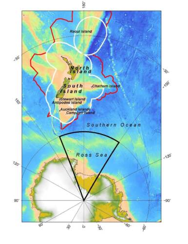
Aotearoa-New Zealand’s land area is just 268,831 km2. But this modest presence in the mid-latitudes belies a much larger marine realm of almost 6 million km2 over which NZ has sovereignty as defined by the United Nations Convention on the Law of the Sea. South of this realm, Aotearoa-NZ has stewardship (but not sovereignty) over ~450,000 km2 of ocean, ice and land of the Ross Dependency. Overall, marine Aotearoa-NZ encompasses subtropical to polar climates, intercepts global ocean currents and is sheared by a major tectonic plate boundary. Such dynamism underpins the claim that the region is a remarkable laboratory to determine how the natural world functions.
A dynamic seabed
About 23 million years ago, tectonic plates in the Southwest Pacific began to move. Today, the boundary between the Pacific and Australian plates shears the submarine continent of Te Riu-a-Māui Zealandia with its extensive plateaux, ridges and rises. That topography is enhanced where plates converge and buckle to create, for example, ocean trenches such as the 10,000 m-deep Kermadec Trench. As plates descend further into Earth’s interior, rocks are heated to form magma that feeds numerous submarine volcanoes. Such stresses also form earthquakes that further modify the seascape through faulting, landslides and transport by sediment-laden flows that carry mud and sand hundreds of kilometres offshore.
Tropical to polar weather and climate
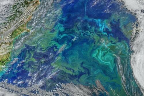
Weather affecting marine Aotearoa-NZ is dominated by the passage of anticyclones driven by the Roaring Forties and Furious Fifties westerly winds. Separating the anticyclones are low pressure troughs that typically herald strong winds and rain. The location and intensity of these weather systems vary with the seasons and longer term climatic influences such as 3-7 year El Niño-La Niña cycles from the tropical Pacific and the circum-polar Southern Annular Mode. Interaction between these and other climatic factors, produces a complex oceanic response. However, trends are still evident. Warm ocean currents now migrate further south under expanding tropical wind regimes. Off Tasmania, for example, warm currents of the South Pacific Gyre, have extended 350 km south since the 1940s to replace subantarctic with subtropical ecosystems.
Polar and subtropical currents
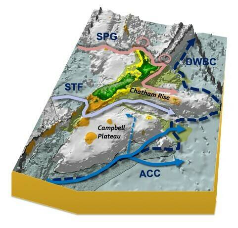
Southern Zealandia intercepts the Antarctic Circumpolar Current that brings cold, polar waters to Aotearoa-NZ. Driven by powerful westerly winds, the ACC flows 24,000 km clockwise around Antarctica. It is Earth’s longest and largest ocean current, and the only one to inter-connect the major oceans. Locally, off Campbell Plateau, the ACC overrides one of the largest deep western boundary currents (DWBCs) that travel north from Antarctica. Together, the ACC and DWBCs dominate the Southern Ocean and are major influences on the global distribution of heat, salt, gases and nutrients.
North of the ACC, the upper ocean is dominated by the South Pacific Gyre. This anticlockwise, wind-driven flow occupies much of the South Pacific Ocean and brings warm subtropical water to our northern and eastern regions.